もくもく単純データ処理に嫌気がさしてきたので
気分転換を兼ねて,
以前相談を受けていて放置していた
TOPEX(Topographic Exposure)の算出を
Grassをつかってやってみました。
GrassでTOPEXを計算,ていうのはこの方がやっていたので参考にしました。
Calculating Togographic Exposure With Grass
もともと俯角はすべて0°とするものだったらしいけど
負の値として計算することもあるようですね。
たとえばこれ(P47-48)
EMPIRICAL MODELLING OF WINDTHROW RISK USING GEOGRAPHIC INFORMATION SYSTEMS
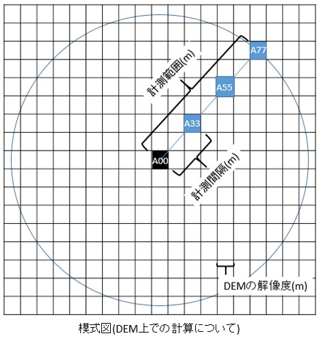
DEMを基にしたTOPEXは
こんな感じで計算するようです。
1) 対象セルA00から8方位の計測線を延ばす
2) その延長上かつ特定の計測範囲内において
一定の間隔でA00からの高低角を算出する
(下図では A00-A33 , A00-A55
およびA00-A77 間の高低角を算出する)
3) 求めた高低角の最大値を
その方位の高低角と定義する
4) 各方位で同様の計算を行い
8方位すべての値を積算したものをTOPEXとする
↓かなりアレな図ですが(平面図です)背景のメッシュはDEMだと思ってください…
どうやら地上開度とアイディアはほとんど同じ。
開度による地形特徴の表示
とりあえず
1)Grass を外部からうごかす環境設定済み
2)DEMはGrassにインポート済み
3)俯角もそのまま計算する(負の値として処理)
という前提で進みます。
引数多すぎとか8方位なのにいらん計算してるとか
そもそもGeotiffのインポートからやれよとか
いろいろあるけど気分転換なので 気にしない 気にしない
ここからダウンロードして解凍
topog フォルダをフォルダごと
windowsであれば
C:\Python27\Lib\
にコピーしてください。
それで
python (command line)
または
コマンドプロンプト(最初にpythonと入力しENTERする)
などで以下のようにコマンドを入力して実行してみてください。
|
1 2 3 4 5 6 |
# モジュールのインポート from topog import topex as t # t.topex("gisdataディレクトリ","ロケーション","マップセット", # "入力DEM名",DEMの解像度(m),計測間隔(m),計測範囲(m),"出力ラスタ名") # 入力例 t.topex("C:\\temp\\grass","hokk","PERMANENT","dem",10,100,2000,"topex_raster") |
topex.pyの中身はこうなっています。
|
1 2 3 4 5 6 7 8 9 10 11 12 13 14 15 16 17 18 19 20 21 22 23 24 25 26 27 28 29 30 31 32 33 34 35 36 37 38 39 40 41 42 43 44 45 46 |
## import module ## import grass.script as grass import grass.script.setup as gsetup import math import os def topex(gisdb,location,mapset,dem,res,interval,range_max,output): # set up grass path # gisbase = os.environ['GISBASE'] # set GRASS gisdatabase, location, mapset # gsetup.init(gisbase, gisdb, location, mapset) # set region as same as input DEM (extent and resolution) grass.run_command("g.region", rast=dem) # calculate pixel based interval interval_p = int(round(interval / res)) # calculate pixel based maximum range range_max_p = int(round(range_max / res)) ## set formula for calculation ## # set initial part of formula formula_t1 = output + " = " # 8 direction as azimuth angle for azi in (0,45,90,135,180,225,270,315): # initial cell number num = 0 formula = "max(" while num < range_max_p: num = num + interval_p x = int(round(math.sin(math.radians(azi))*num)) y = int(round(math.cos(math.radians(azi))*num)) formula = formula + "atan((" + dem + "[" + str(y) + "," + str(x) + "] - " + dem + ") / (" + str(res) + " * " + str(num) + "))," # build formula for calculating max elevation angle at each direction formula_t = formula[0:-1] + ")" # build formula for summing up value at all direction formula_t1 = formula_t1 + formula_t + " + " # build formula for r.mapcalc formula_f = formula_t1[0:-3] print formula_f ## run r.mapcalc command ## grass.run_command("r.mapcalc_wrapper",expression = formula_f) print "finish" if __name__ == '__main__': print "this is code block" |
環境変数の設定とかめんどくせ という場合は
同梱してあるtopexf.pyを使って
1)出力コマンドをテキストファイルに出力
2)grassのレイヤマネージャにあるコマンドコンソールにコピペして実行
てのがてっとりばやくて楽かもしれないですね。
これはpython2xがあれば動きます。
|
1 2 3 4 5 |
# モジュールのインポート from topog import topexf as t # t.topexf("入力DEM名",DEMの解像度(m),計測間隔(m),計測範囲(m),"出力ラスタ名","出力テキストファイル(フルパス)") # 入力例 t.topex("dem",10,100,2000,"topex_raster01","C:\\temp\\topex_command.txt") |
topexf.pyの中身はこうなっています。
|
1 2 3 4 5 6 7 8 9 10 11 12 13 14 15 16 17 18 19 20 21 22 23 24 25 26 27 28 29 30 31 32 33 34 35 36 37 38 39 |
## import math module ## import math def topexf(dem,res,interval,range_max,output,out_formula): # calculate pixel based interval interval_p = int(round(interval / res)) # calculate pixel based maximum range range_max_p = int(round(range_max / res)) ## set formula for calculation ## # set initial formula formula_t1 = output + " = " for azi in (0,45,90,135,180,225,270,315): # initial cell number num = 0 formula = "max(" while num < range_max_p: num = num + interval_p x = int(round(math.sin(math.radians(azi))*num)) y = int(round(math.cos(math.radians(azi))*num)) formula = formula + "atan((" + dem + "[" + str(y) + "," + str(x) + "] - " + dem + ") / (" + str(res) + " * " + str(num) + "))," # build formula for calculating max elevation angle at single direction formula_t = formula[0:-1] + ")" # build formula for summing up value at all direction formula_t1 = formula_t1 + formula_t + " + " # build formula for r.mapcalc formula_f = formula_t1[0:-3] print formula_f f = open(out_formula, 'w') f.write("r.mapcalc '" + formula_f + "'") f.close() print "finish" if __name__ == '__main__': print "this is code block" |
コメントはかなり適当(ごめんなさい)
これみたいにGDALでやったほうがべんりなんだろうなー
gdalでfocal statistics
ではでは。

